
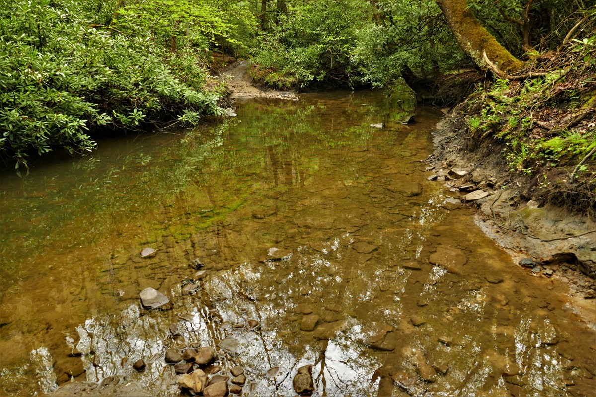
Driving between Pocahontas and Boissevain in southwestern Virginia, it’s easy to miss the mouth of Haynes Branch tucked into the woods along State Route 644. Like much of central Appalachia, this landscape of hills and hollows west of the Bluestone River in Tazewell County owes its existence to water. There’s a creek coming off a hillside seemingly every few feet, and the layout of the two historic coal towns traces the streambanks as they thread eastward.
A one-lane dirt path leaves the blacktop on the eastern edge of Boissevain – an unincorporated former coal town – turning up Haynes Branch a mile later. The waterway is a classic Appalachian headwater stream, fanning out across a rhododendron-blanketed cove into rivulets that alternate above and belowground, never more than a steady trickle outside of periods following heavy rain.
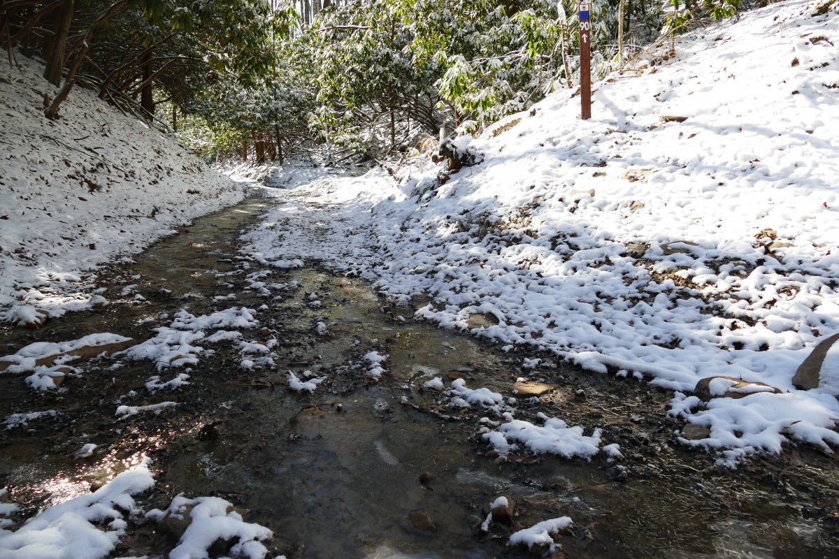
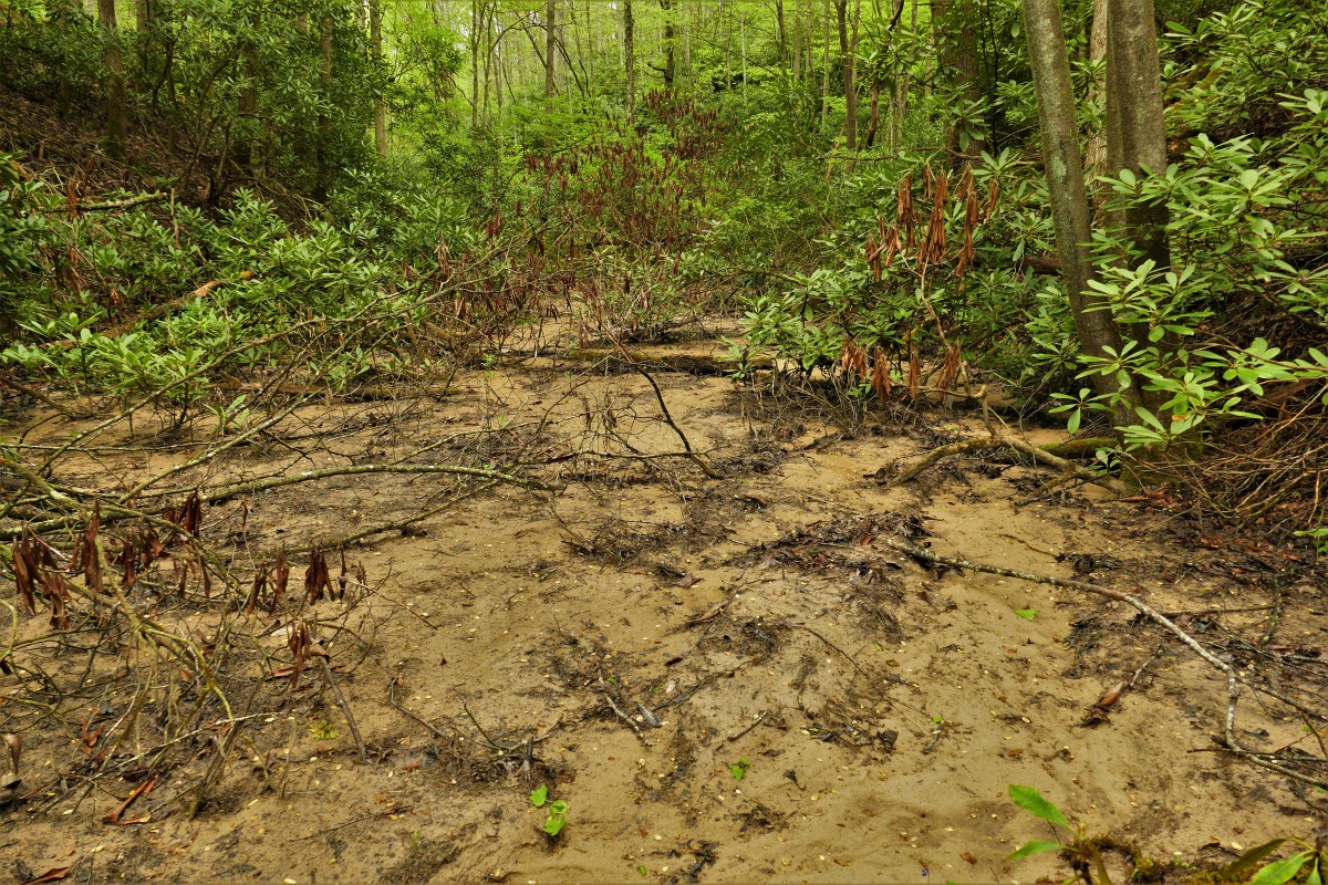
As you travel across those headwaters, though, it becomes apparent that something isn’t right. The upper reaches of the creek don’t tumble from pool to pool but instead stream down tire ruts. Salamanders wander across mud slicks; sand and silt bury portions of the forest floor. During wet weather, numbered trail signs bearing the logo of Virginia’s Original Pocahontas Trail point off-road vehicles up flowing water for half a mile.
Headwater streams like Haynes Branch have long been an environmental flashpoint in Appalachia. Outcry over the loss of such waterways through mountaintop removal mining has raged for decades, while stream crossings have played a pivotal role in ongoing battles over pipeline projects in Virginia and West Virginia.
But in the background of those high-profile issues, rapidly-expanding recreational development has quietly been disturbing similar streams – attracting the eye of regulatory agencies and highlighting the growing complexities of Appalachia’s changing economy.
Situations like the one on Haynes Branch have played out on public off-road vehicle trails across central Appalachia, which collectively exceed 1,000 miles in length. Routes like the one near Boissevain — lengths of streambeds excavated into forest roads or signed for vehicle use — have become popular features on several trail systems, many of which are managed by state government authorities as part of bids to transition Appalachian communities away from coal. State legislatures in Virginia, West Virginia and Tennessee have already established public trail authorities, with a similar authority in its infancy in eastern Kentucky.
Off-roading is a cultural mainstay in Appalachia and a natural fit for economic transitioning efforts. The region contains an abundance of large parcels of private land, many owned by industry groups, that have historically been the focus of unorganized off-road use.
The concept behind developing state-managed trails on these lands is straightforward: Public authorities adopt existing trails and construct connecting routes as tourism assets, opening them to users who pay an access fee. The strategy has been a godsend for struggling communities across the region, generating millions in tourism revenue and fueling the growth of myriad small businesses.
However, many of the roadbeds grandfathered into public trail systems were constructed decades ago, sometimes borrowing streambeds along the way. Others were built for limited use by extractive industry, lacking the environmental controls necessary to support heavy recreational traffic.
As a biologist working with aquatic wildlife, my colleagues and I often end up in many of these disturbed habitats across central Appalachia. Over the past several years, we’ve encountered several miles of streambeds and acres of wetlands that have been incorporated into state-managed off-road trail systems in the Virginia coalfields alone. Most occur upstream of homes or communities’ downtowns, with several on public properties and parcels managed by conservation organizations.
While splashing up a creek with an ATV might seem harmless, putting hundreds of recreational users per year into a stream can be disastrous for water quality. Studies of public off-road trails in southern Appalachia have found that sections of trail flanking an unbridged stream crossing can contribute nearly a ton of sediment per acre to the stream annually. Separate studies have found that sediment loads downstream of motorized and non-motorized trail systems in the region were multiple times higher than in nearby, unimpacted streams.
Increased sediment matters because it can suffocate aquatic wildlife and increase the costs of treating drinking water for downstream communities. The U.S. Department of Agriculture’s Forest Service, for example, closed its Upper Tellico Off-Road Trail System in western North Carolina in 2009 over concerns that sediment was decimating brook trout populations. In 2016, the U.S. Fish and Wildlife Service highlighted West Virginia’s Hatfield-McCoy Trails in its decision to protect two native crayfish under the Endangered Species Act. In-stream vehicle use and associated sedimentation were cited by officials as a factor threatening the Guyandotte River Crayfish with extinction.
As trail systems have expanded, so has confusion about how the industry should be regulated by state and federal agencies. After images appeared online in 2018 showing ATVs and construction equipment in streams along southwest Virginia’s Spearhead Trails system, nearby residents raised concerns to the Virginia Department of Environmental Quality. Officials concluded that trail networks were mostly outside of any regulatory purview.
“I want you to know our office has investigated previous complaints,” an official wrote to one complainant in records released to the public by the agency last year, “and discovered there is very little that is regulated under our current laws and regulations concerning recreational trails.”
Just a few months later, however, DEQ sent a memo to Virginia’s Southwest Regional Recreation Authority detailing that recreational trails were subject to numerous environmental laws. In an email later released along with the memo, agency officials explained that the decision was necessary due to “recent incidents where the law and regulations have allegedly not been followed.”
Since that time, though, DEQ has reported no enforcement on the state’s trail systems, nor have any relevant permits been listed in its public database, even as new off-road trails have come online. Meanwhile, public records show that recreation authority officials have explored amending Virginia law to exempt trail systems from stormwater regulations designed to protect communities’ water quality.
To be clear, trails of all types play a valuable role in Appalachia’s economic landscape, just as outdoor activities like off-roading deserve to remain a part of our regional identity. However, we must ensure that our tourism efforts do not create costly environmental liabilities for our most vulnerable communities. That means making the trail planning process public and transparent, adapting to feedback from nearby residents and natural resource professionals. Legislators and funding agencies can require trail authorities to publish regular environmental audits and adopt industry best management practices, such as avoiding aquatic habitats and using engineered stream crossing structures. Clear regulatory guidance and consistent enforcement from environmental agencies is also needed to steer responsible trail construction.
There are encouraging signs of progress across several corners of Appalachia, though. The U.S. Fish and Wildlife Service announced earlier this year that they were partnering with the Hatfield-McCoy Regional Recreation Authority to address water quality impacts on its trail systems. And in late 2019, host landowners closed several segments of Virginia’s Spearhead Trails system that had for years allowed vehicles to drive up streams in the Clinch River and Russell Fork watersheds — the former containing some of the continent’s highest levels of imperiled freshwater wildlife.
Those actions show that it’s possible for tourism efforts to succeed while protecting natural resources. But as a growing number of communities’ waterways show, we still have work to do, and it’s up to our outdoor leaders to ensure that these symbols of our natural heritage don’t remain forgotten.
Wally Smith is a biologist and writer living and working in Wise, Virginia. His work focuses on the overlap between wildlife conservation and economic development in rural Appalachia. The opinions expressed in this piece are his own and do not necessarily reflect those of any organization, agency, or employer.